

Home |
Temáticas |
Catálogos |
Pedidos |
| |
|||||||
|

|
RUGENDAS. (Johann Moritz) HABITANTE DE GOYAS, QUADRO A ÓLEO PINTADO SOBRE MADEIRA. |
|
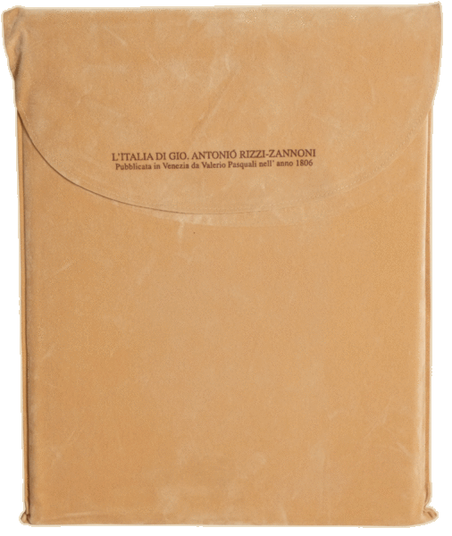
Clique nas imagens para aumentar. RIZZI-ZANNONI. (Giovanni Antonio) L'ITALIA Di Gio. Antonio Rizzi-Zannoni. [FAC-SIMILE DO MAPA DE ITÁLIA, EDIÇÃO DE VENEZA, 1806]In quattro fogli imperiali con l’aggiunta dei luoghi e le strade postali. Publicata da Gio. Valerio Pasquali. All’ill.mo Sig. Ab Daniele Dr. Francesconi, accademico e bibliotecario di Padova, Conoscitore e Protettore delle belle Arti, l’editore in segno di riconoscenza D.D. D. Venezia MDCCCVI. [1806] De 114x82 cm. Acondicionada numa bolsa de veludo colocada numa caixa de cartão revestida de tela vermelha com a identificação da obra em tarja impressa no canto superior esquerdo. O título transcrito acima está numa bela cartela Na margem inferior direita consta: Gio. Valerio incise Venezia l’anno 1806. No canto inferior esquerdo contém uma cartela com a correspondência entre as milhas usadas em vários países europeus e nos diversos estados da Itália e na margem esquerda o meridiano de que serviu de referência. A escala usada foi cerca de 1:248 000. Magnífica reprodução fac-similada do célebre mapa de Itália elaborado por Rizzi-Zannoni e publicado, em 1806, em Veneza, em que ao material da edição de Florença de 1802 acrescentou as estradas e as estações postais. O fac-simile foi impresso sobre papel especial de algodão com uma suavidade e flexibilidade excepcional, que por sua vez foi montado numa tela também de algodão. Todos os exemplares foram impressos com torno manual, as folhas foram coloridas à mão e sujeitas a um processo de envelhecimento, com base em substâncias vegetais, executado manualmente, possibilitando assim que cada exemplar tenha leves diferenças dos outros tal como na edição original. Giovanni Antonio Bartolomeo Rizzi-Zannoni (Pádua, 1736 - Nápoles, 1814) Geógrafo e cartógrafo. Estudou com Giovanni Poleni. Em 1753 elaborou um mapa da Polónia por encomenda do Rei Augusto III. Trabalhou na Dinamarca, Suécia e na Prússia. Quando estava ao serviço deste último país foi capturado pelos franceses na batalha de Rossbach, em 1757 e passou os vinte anos seguintes a trabalhar em Paris, onde colaborou no Atlas Moderne. Em 1781 mudou-se para Nápoles, onde recebeu a comissão de rever a carta geográfica do Reino de Nápoles de 1769, que resultou na publicação de L'Atlante Geografico del Regno di Napoli, com mais de 32 folhas, que completou em 1812. Realizou grande número de cartas geográficas de quase todos os países da Europa, incluindo uma carta geográfica do Reino de Portugal, publicada em Veneza no ano de 1802, com o título - Les Royaumes de Portugal et d'Algarve.
The title transcribed above is on a beautiful card in the bottom right-hand margin: Gio. Valerio incise Venezia l’anno 1806. In the bottom left-hand corner is a chart showing the correspondence between the miles used in various European countries and in the various states of Italy, and in the left-hand margin the meridian used as a reference. The scale used was around 1:248,000. Magnificent facsimile reproduction of the famous map of Italy drawn up by Rizzi-Zannoni and published in 1806 in Venice, in which he added the roads and post offices to the material in the Florence edition of 1802. The facsimile was printed on special cotton paper with exceptional softness and flexibility, which in turn was mounted on a cotton canvas. All the copies were printed on a manual lathe, the sheets were coloured by hand and subjected to an ageing process, based on vegetable substances, carried out by hand, thus making it possible for each copy to have slight differences from the others, just as in the original edition. Giovanni Antonio Bartolomeo Rizzi-Zannoni (Padua, 1736 - Naples, 1814) Geographer and cartographer. He studied with Giovanni Poleni. In 1753 he drew up a map of Poland on commission from King Augustus III. He worked in Denmark, Sweden and Prussia. While in the service of the latter country he was captured by the French at the Battle of Rossbach in 1757 and spent the next twenty years working in Paris, where he collaborated on the Atlas Moderne. In 1781 he moved to Naples, where he was commissioned to revise the 1769 geographical map of the Kingdom of Naples, which resulted in the publication of L'Atlante Geografico del Regno di Napoli, with more than 32 sheets, which he completed in 1812. He produced a large number of geographical maps of almost every country in Europe, including a geographical map of the Kingdom of Portugal, published in Venice in 1802 under the title - Les Royaumes de Portugal et d'Algarve. Referências/References: IT/ICCU/CFI/0896456 (Edição original) Referência: 2310PG008
Local: M-2-B-23 Caixa de sugestões A sua opinião é importante para nós. Se encontrou um preço incorrecto, um erro ou um problema técnico nesta página, por favor avise-nos. 
Outras Sugestões
|
Pesquisa Simples


|
|||||||
 |
||||||||
|
 English
 114x82 cm. Packaged in a velvet pouch placed in a red canvas-covered cardboard box with the work's identification printed in the top left-hand corner.