
Home |
Temáticas |
Catálogos |
Pedidos |
| |
|||||||
|

|
RUGENDAS. (Johann Moritz) HABITANTE DE GOYAS, QUADRO A ÓLEO PINTADO SOBRE MADEIRA. |
|
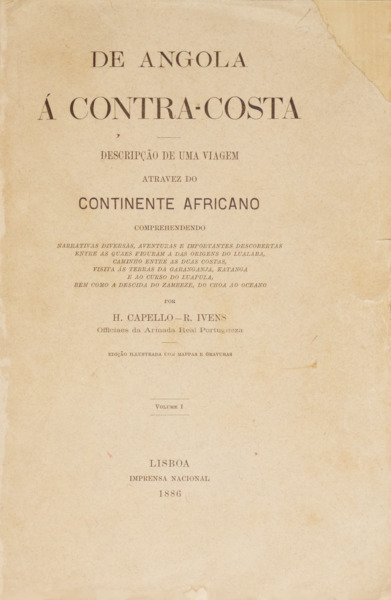
Clique nas imagens para aumentar. BRITO CAPELO. (Hermenegildo Carlos de) e Roberto Ivens. DE ANGOLA À CONTRA-COSTA.Descripção de uma viagem atravez do CONTINENTE AFRICANO comprehendendo narrativas diversas, aventuras e importantes descobertas entre as quaes figuram a das origens do Lualaba, caminho entre as duas costas, visita ás terras da Garanganja, Katanga e ao curso do Luapula, bem como a descida do Zambeze, do Choa ao oceano. Por H. Capello - R. Ivens Officiaes da Armada Real Portugueza. Edição illustrada com mappas e gravuras. Volume I [Volume II]. Imprensa Nacional. Lisboa. 1886. 2 Volumes de 24x17,5 cm. Com xxvii, 448, [i]; xiii, [i em br], 490, [ii em br] págs. Encadernações com lombadas e cantos em pele, com nervos, rótulos e ferros a ouro nas lombadas. Incluem fita em cetim e folhas de guarda marmoreadas a imitar o antigo. Ilustrados com gravuras a preto e branco, com 14 em extratexto, 4 no primeiro volume e 10 no segundo, uma das quais de página dupla, 2 desdobráveis com diagramas de curvas meteorológicas e 6 mapas desdobráveis, com 4 no primeiro volume e 2 no segundo. Incluem quadros estatísticos e meteorológicos. Exemplar aparado apenas à cabeça, ocasionais picos de acidez e manchas de humidade, preserva a capa de brochura anterior com restauro no canto superior do primeiro volume e capa posterior do segundo volume. Primeira edição, dedicada a Dom Luís I, ao Povo Português e a Manuel Pinheiro Chagas, com prefácio dos autores. Relato fundamental da grande expedição de Capelo e Ivens (1884-1885), esta obra monumental documenta a travessia científica e cartográfica entre Angola e Moçambique, consolidando a presença portuguesa no interior de África e servindo de base ao célebre Mapa Cor-de-Rosa, marco geopolítico do fim do século XIX. Páginas em numeração romana do primeiro volume com dedicatórias, quadro com a relação dos indivíduos perdidos durante a expedição ao interior de África, índice das gravuras e dos capítulos, e prefácio. Segundo volume com índice das gravuras e dos capítulos nas páginas preliminares; e índice geográfico, antroponímico e das matérias dos volumes nas páginas finais. A obra divide-se em 30 capítulos, primeiro volume do Capítulo I ao XVI (1-16), segundo do Capítulo XVII ao XXX (17-30). Em 19 de Abril de 1883, o então Ministro da Marinha e do Ultramar, Manuel Pinheiro Chagas, decretou a criação de uma Comissão de Cartografia com o objectivo de elaborar um atlas geral das colónias portuguesas. Paralelamente, visava-se o estabelecimento de uma rota comercial terrestre entre Angola e Moçambique. Como os territórios a atravessar eram ainda desconhecidos e careciam de levantamento cartográfico, recorreu-se a oficiais da Marinha, experientes em missões de exploração, capazes de avançar com maior rapidez através da aplicação dos princípios da navegação marítima ao interior africano. Numa fase inicial, a exploração decorreu entre a costa e o planalto da Huíla, prosseguindo depois pelo interior do continente até Quelimane, em Moçambique. Durante esta travessia, os exploradores continuaram os seus estudos hidrográficos, realizando também registos de carácter geográfico-natural, etnográfico e linguístico. Foi assim estabelecida a tão ambicionada ligação terrestre entre as costas de Angola e Moçambique, com a exploração das vastas regiões do interior entre os dois territórios, descritas detalhadamente nesta obra. A missão teve início a 6 de Janeiro de 1884 e terminou a 20 de Setembro de 1885, data em que os exploradores regressaram a Lisboa, sendo recebidos em triunfo pelo rei D. Luís. Roberto Ivens (São Pedro, Ponta Delgada, 1850 — Dafundo, Oeiras, 1898), filho de pai inglês e de mãe açoriana, foi um oficial da Armada, administrador colonial e explorador do continente africano, português. Concluiu o curso de Marinha em 1870 com as mais elevadas classificações, no ano seguinte frequentou a Escola Prática de Artilharia Naval, partindo em setembro para a Índia, pelo Canal do Suez, integrado na guarnição da corveta Estefânia, onde é feito guarda-marinha. A partir de 1872 inicia contactos regulares com o continente africano, ascende a diversos cargos e termina a sua carreia como Oficial.
Illustrated with black and white engravings, with 14 Hors-texte, 4 in the first volume and 10 in the second, one of which is a double-page, 2 fold-outs with diagrams of meteorological curves and 6 fold-out maps, 4 in the first volume and 2 in the second. Includes statistical and meteorological tables. Copy trimmed only at the head, ocasional foxing and damp stains. Preserves the previous paperback cover with restoration at the top corner of the first volume and back cover of the second volume. 1st Edition, dedicated to Dom Luís I, the Portuguese People and Manuel Pinheiro Chagas, with a preface by the authors. Roman-numbered pages of the first volume with dedications, a table listing the individuals lost during the expedition to the interior of Africa, an index of the engravings and chapters, and a preface. Second volume with an index of the engravings and chapters on the preliminary pages; and a geographical, anthroponymic and material index of the volumes on the final pages. The work is divided into 30 chapters, the first volume from Chapter I to XVI (1-16), the second from Chapter XVII to XXX (17-30). Report of the exploration carried out between 1884 and 1885 by Capelo and Ivens, first between the coast and the Huíla plateau and then through the interior to Quelimane in Mozambique. They then continued their hydrographic studies, making geographical records, as well as ethnographic and linguistic ones. They thus established the much-desired land link between the coasts of Angola and Mozambique, exploring the vast inland regions situated between these two territories, described in this book. The mission began on 6 January 1884 and the explorers returned on 20 September 1885 to a triumphant welcome from King Luís. On 19 April 1883 Manuel Pinheiro Chagas, Minister of the Navy and Overseas Territories, created a Cartography Commission by decree, with the aim of creating a general atlas of the Portuguese colonies. On the other hand, it was also intended to create a trade route linking Angola to Mozambique by land. As the territories to be crossed were unknown and needed to be mapped, naval officers were used who, having previous experience in this type of exploration, could make faster progress using the principles of maritime navigation. With the creation of this link, there was also some kind of claim to sovereignty over the lands between the two colonies, which today are the territories occupied by Zambia, Zimbabwe and Malawi. This claim is known as the Pink Map, the idea of which is attributed to the then Minister of Foreign Affairs, Henrique de Barros Gomes, who, however, never admitted that it was his idea. This was in clear collision with the British objective of linking Cairo to Cape Town and triggered a dispute between the Portuguese state and Great Britain that culminated in the British Ultimatum of 1890 to which Portugal gave in, causing serious damage to the image of the Portuguese monarchical government. Hermenegildo Carlos de Brito Capelo (Palmela, 1839 - Lisbon, 1917), was a Portuguese naval officer and explorer of the African continent during the last quarter of the 19th century. In 1860 he embarked as a marine guard for Angola aboard the corvette D. Estefânia, commanded by Prince Luís. In 1863 he returned to Lisbon and was approved Second Lieutenant. In 1874 he became First Lieutenant, Captain Lieutenant supernumerary in 1877, and Frigate Captain in 1884. Honorary Aide-de-Camp to His Majesty the King, Commander of the Order of St James. As a result of scientific exploration in Africa with another distinguished naval officer, Mr Roberto Ivens, he wrote and published the following work: De Benguella ás Terras de Iácca. Lisbon, Imp. Nacional, 1881. Roberto Ivens (São Pedro, Ponta Delgada, 1850 - Dafundo, Oeiras, 1898), son of an English father and Azorean mother, was a Portuguese naval officer, colonial administrator and explorer of the African continent. He graduated from the Navy in 1870 with the highest marks. The following year he attended the Practical School of Naval Artillery, leaving in September for India, via the Suez Canal, as part of the garrison of the corvette Estefânia, where he was made a marine guard. From 1872 he began regular contacts with the African continent, rose to various positions and ended his career as an officer. Referências/References: Inocêncio XI, 261-262; XVIII, 352. Referência: 2406RS168
Local: M-19-C-1 Caixa de sugestões A sua opinião é importante para nós. Se encontrou um preço incorrecto, um erro ou um problema técnico nesta página, por favor avise-nos. 
Outras Sugestões
|
Pesquisa Simples


|
|||||||
 |
||||||||
|
 English
 2 Volumes in folio. 24x17,5 cm. xxvii, 448, [i]; xiii, [i in bl], 490, [ii in bl] pp. Binding with leather spines and corners, raised bands, labels and gilt tooled on spine. With satin ribbon marker and recent marbled endpapers in contemporary style.