
Home |
Temáticas |
Catálogos |
Pedidos |
| |
|||||||
|

|
RUGENDAS. (Johann Moritz) HABITANTE DE GOYAS, QUADRO A ÓLEO PINTADO SOBRE MADEIRA. |
|
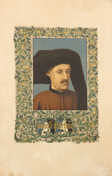
Clique nas imagens para aumentar. MAJOR. (Richard Henry) THE LIFE OF PRINCE HENRY OF PORTUGAL, SURNAMED THE NAVIGATOR;And its results: comprising the discovery, within one century, of half the world. With new facts in the discovery of the Atlantic Islands; a refutation of French claims to priority in discovery; Portuguese knowledge (subsequently lost) of the Nile Lakes; and the history of the naming of America. From Authentic Cotemporary Documents. By Richard Henry Major, F.S.A., F.R.S.L., etc. Keeper of the Department of Maps and Charts in the British Museum, Hon. Sec. of the Royal Geographical Society. Illustrated with portraits, maps, etc. A. Asher & Co. London and Berlin. 1868. De 26x18 cm. Com [iv], lii, 487, [i em br.] págs. Encadernação editorial em tela encerada verde, com gravações a ouro na lombada e na pasta anterior e esquadrias simples nas pastas a seco. Na pasta anterior está gravado um super-libros alusivo ao infante Henrique: a letra H com um pendente com a cruz de Cristo e uma coroa, encimada pela célebre divisa: «Talant de Bien Faire». Ilustrado em face da folha de rosto com um retrato colorido do Infante D. Henrique e em extratexto com 12 gravuras sobre folhas de papel couché, das quais 7 são mapas a duas cores, incluindo a reprodução de mapas antigos e três desdobráveis: retrato de Filipa de Lencastre; mapa de Ceuta; planta do Forte e Promontório de Sagres; retrato do rei João I; mapa desdobrável «Africa from the Laurentian Portulano - 1351»; túmulo do Infante Henrique; estátua do Infante no Mosteiro de Belém; monumento ao Infante em Sagres; mapa hidrográfico de África por Duarte Lopez Congo, datado de Roma, 1591; mapa da obra «On the Discovery of Australia by the Portuguese in 1601»; mapa desdobrável de Java «Australia from the Dauphin Map» c. 1530; mapa desdobrável de grandes dimensões (de 52x60 cm.) de África com as viagens dos portugueses no século XVI. Tem também uma reprodução da assinatura do Infante Henrique no texto. Impressão nítida sobre papel de muita boa qualidade e de margens largas. Exemplar com etiquetas de posse no verso da pasta anterior, incluindo uma dos livreiros «S. & T. Gilbert», e da Livraria Académica do Porto na guarda anterior. Etiqueta do encadernador no verso da pasta posterior. Apresenta dois pequenos rasgos no último mapa desdobrável. Muito rara primeira edição desta obra clássica cuja escassez já era reconhecida por Borba de Moraes. A segunda edição, mais comum, foi impressa por Sampson Low, Londres, 1877, sob o título: «The Discoveries of Prince Henry the Navigator, and their Results». Foi traduzida para o português por José António Ferreira Brandão e impressa pela Imprensa Nacional, Lisboa, 1876. Uma obra essencial para qualquer estudioso ou apaixonado pela Era dos Descobrimentos, sendo uma das primeiras biografias detalhadas do Infante D. Henrique escritas em inglês. Referência autoritativa sobre as viagens e descobertas portuguesas dos séculos XV e XVI. Preliminares em numeração romana com dedicatória do autor a Francisco de Almeida, 2.º Conde do Lavradio, índice de conteúdos e um extenso prefácio. Inclui um extenso índice remissivo nas páginas 455 a 483 e a bibliografia consultada nas 484 a 487. Citação dos Lusíadas no verso da folha de rosto. Baseando-se em manuscritos raros, alguns analisados pela primeira vez nesta obra, Richard Henry Major conduz o leitor através da transformação de Portugal numa potência naval, desvendando os bastidores da conquista de Ceuta, a fundação da mítica Escola de Sagres e as ousadas expedições que abriram caminho para a exploração da costa africana. Com um olhar crítico e erudito, o autor refuta alegações estrangeiras sobre precedência em descobertas, reexamina a cronologia da expansão atlântica e realça o impacto intelectual do Infante no avanço da navegação. A obra não só traça a trajetória do Infante, como também situa os seus feitos no contexto global da exploração, explorando desde as primeiras tentativas de dobrar o Cabo Bojador até à influência indireta da sua visão estratégica na chegada de Vasco da Gama à Índia, na descoberta da América por Colombo e na circum-navegação de Fernão de Magalhães. Richard Henry Major (Londres, 1818 – Londres, 1891) foi um conceituado geógrafo, historiador e cartógrafo britânico. Iniciou a sua carreira no Museu Britânico em 1844, assumindo a responsabilidade pelas coleções de mapas e cartas náuticas. Em 1867, tornou-se o primeiro conservador do recém-criado departamento de mapas e planos impressos, posição que ocupou até 1880. Major também desempenhou papéis significativos em instituições geográficas de renome, servindo como secretário honorário da Hakluyt Society de 1849 a 1858 e como vice-presidente da Royal Geographical Society entre 1881 e 1884. Entre as suas contribuições académicas, destacam-se, além da presente obra, «Select Letters of Christopher Columbus» (1847) e «Early Voyages to Terra Australis» (1859). Foi também editor de mapas e documentos relevantes da era colombiana. O seu trabalho «On the Discovery of Australia by the Portuguese in 1601» (1863) argumenta que os navegadores portugueses foram os primeiros a descobrir a Austrália, antes dos holandeses.
Illustrated on the title page with a coloured portrait of Prince Henry the Navigator and with 12 hors-texteengravings on coated paper, 7 of which are two-colour maps, including reproductions of old maps and three fold-outs: portrait of Filipa de Lencastre; map of Ceuta; plan of the Sagres Fort and Promontory; portrait of King João I; fold-out map 'Africa from the Laurentian Portulano - 1351'; tomb of Prince Henry; statue of the Prince in the Belém Monastery; monument to the Prince in Sagres; hydrographic map of Africa by Duarte Lopez Congo, dated Rome, 1591; map from the work 'On the Discovery of Australia by the Portuguese in 1601'; fold-out map of Java 'Australia from the Dauphin Map' c. 1530; large fold-out map (52x60 cm) of Africa with the voyages of the Portuguese in the 16th century. There is also a reproduction of Henry the Navigator"s signature in the text. Clear printing on very good quality paper with wide margins. Copy with ownership labels on the front pastedown, including one from the 'S. & T. Gilbert' booksellers, and one from Livraria Académica do Porto on the verse of the first flyleaf. Binder"s label on the rear pastedown. There are two small tears in the last fold-out map. Very rare first edition of this classic work whose scarcity was already recognised by Borba de Moraes. The more common second edition was printed by Sampson Low, London, 1877, under the title: 'The Discoveries of Prince Henry the Navigator, and their Results'. It was translated into Portuguese by José António Ferreira Brandão and printed by Imprensa Nacional, Lisbon, 1876. An essential work for any scholar or enthusiast of the Age of Discovery, it is one of the first detailed biographies of Prince Henry written in English. An authoritative reference on the Portuguese voyages and discoveries of the 15th and 16th centuries. Preliminaries in Roman numerals with the author"s dedication to Francisco de Almeida, 2nd Count of Lavradio, an index of contents and an extensive preface. Includes an extensive reference index on pages 455 to 483 and the bibliography consulted on pages 484 to 487. Quotation from the Lusiads on the back of the title page. Based on rare manuscripts, some analysed for the first time in this book, Richard Henry Major takes the reader through the transformation of Portugal into a naval power, unveiling the backstage of the conquest of Ceuta, the founding of the mythical School of Sagres and the daring expeditions that paved the way for the exploration of the African coast. With a critical and erudite eye, the author refutes foreign claims about precedence in discoveries, re-examines the chronology of Atlantic expansion and emphasises the Infante"s intellectual impact on the advancement of navigation. The book not only traces the Prince"s trajectory, but also places his achievements in the global context of exploration, exploring everything from the first attempts to double Cape Bojador to the indirect influence of his strategic vision on Vasco da Gama"s arrival in India, Columbus"s discovery of America and Ferdinand Magellan"s circumnavigation. Richard Henry Major (London, 1818 - London, 1891) was a renowned British geographer, historian and cartographer. He began his career at the British Museum in 1844, taking responsibility for the collections of maps and nautical charts. In 1867, he became the first curator of the newly created department of printed maps and plans, a position he held until 1880. Major also played significant roles in renowned geographical institutions, serving as honorary secretary of the Hakluyt Society from 1849 to 1858 and as vice-president of the Royal Geographical Society between 1881 and 1884. His academic contributions include, in addition to the present work, 'Select Letters of Christopher Columbus' (1847) and 'Early Voyages to Terra Australis' (1859). He was also the editor of relevant maps and documents from the Columbian era. His work 'On the Discovery of Australia by the Portuguese in 1601' (1863) argues that the Portuguese navigators were the first to discover Australia, before the Dutch. Referências/References: Referência: 2502SB003
Local: M-9-E-72 Caixa de sugestões A sua opinião é importante para nós. Se encontrou um preço incorrecto, um erro ou um problema técnico nesta página, por favor avise-nos. 
Outras Sugestões
|
Pesquisa Simples


|
|||||||
 |
||||||||
|
 English
 26x18 cm. [iv], lii, 487, [i in bl.] pages. Editorial binding in green waxed canvas, with gold engravings on the spine and on the front board and simple blind tooled frames on the covers. The front board is engraved with a super-libris alluding to Henry the Navigator: the letter H with a pendant bearing the cross of Christ and a crown, surmounted by the famous motto: 'Talant de Bien Faire'.