

Home |
Temáticas |
Catálogos |
Pedidos |
| |
|||||||
|

|
RUGENDAS. (Johann Moritz) HABITANTE DE GOYAS, QUADRO A ÓLEO PINTADO SOBRE MADEIRA. |
|
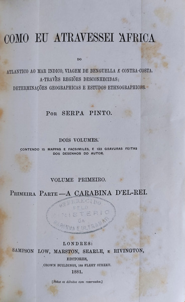
Clique nas imagens para aumentar. SERPA PINTO. (Major Alexandre Alberto) COMO EU ATRAVESSEI ÀFRICAdo Atlantico ao mar indico, viagem de Benguela á contra-costa. A-travès regiões desconhecidas; determinações geográphicas e estudos ethnographicos. Por… Dois volumes. Contendo 15 mappas e facsimiles e 133 gravuras feitas dos desenhos do autor. [Volume Primeiro. Primeira Parte – A Carabina d’El-Rei. Volume segundo. Segunda Parte – A Familia Coillard]. Londres; Sampson Low, Marston, Searle, e Rivington, Editores, Fleet Street. Londres. 1881. 2 volumes de 23x15 cm. Com xxiv, 336 e vi, 340 págs. Encadernações do editor com belas decorações estampadas e titulos dourados nas lombadas e nas pastas. Ilustrado no texto e em extratexto com 139 gravuras (das quais 24 são de página inteira em extratexto), 9 mapas em extra-texto, sendo 3 desdobraveis e coloridos, e ainda 4 fac-símiles em 2 fólios desdobráveis. Obra de grande qualidade gráfica profusamente ilustrada no texto e em extratexto com desenhos antropologicos e etnograficos, flora, culturas agricolas, fauna, vistas de povoações, paisagens naturais, mapas, etc. etc. As 139 gravuras e os 4 fac-símiles em 2 fólios distribuem-se ao longo do texto: 93 (7 de página inteira em extratexto) no primeiro volume e 46 (17 de página inteira em extratexto e 4 fac-símiles em 2 fólios) no segundo volume. Os 9 mapas apresentam o percurso da viagem assinalado: com 8 mapas em extratexto no primeiro volume (entre os quais 2 mapas desdobráveis coloridos, encontrando-se 1 mapa em extratexto, antes da folha de rosto e um outro mapa desdobravel de 70x100 cm, o qual descrevemos seguidamente, acondicionado em estojo proprio dentro da guarda posterior do primeiro volume) e um mapa colorido das Cataratas de Vitória (Mosi-oa-tunia), ou Victoria Falls, em extratexto no segundo volume; e ainda 4 facsimiles em 2 fólios extratexto desdobráveis, reproduzindo 3 páginas do diario da viagem e uma carta geografica manuscrita no mesmo, e ainda 5 mapas impressos no texto. Mapa desdobravel com o título “AFRICA TROPICAL E AUSTRAL MOSTRANDO A VIAGEM DE EXPLORAÇÃO DO MAJOR SERPA PINTO DE 1877 A 1879” na escala de 11 cm=250 milhas inglesas (sendo 1 milha inglesa=1609 metros), colorido com as poucas fronteiras coloniais portuguesas e inglesas da época, apresenta o percurso do explorador delineado e a escala vertical do percurso com altitudes em metros, desde Benguela na costa atlântica até Durban na costa índica. O mapa foi impresso na imprensa da mesma casa editora da obra e apresenta ligueiros rasgos em algumas dobras, sem qualquer perda gráfica. Exemplar em bom estado de conservação, apresentando leves picos de acidez propria do papel, carimbo oleografico coevo de oferta do Ministério da Marinha e Ultramar na folha de rosto do primeiro volume, assinatura de posse coeva na folha de dedicatória do primeiro volume e pequeno rasgão marginal sem perda de papel, nas páginas 101 a 104, que se encontram por abrir. Obra sobre a viagem que Serpa Pinto iniciou em 1877 com os oficiais da marinha portuguesa Capelo e Ivens com o objectivo de reconhecer o interior do continente africano. Partiram de Benguela, na Costa Atlântica e - enquanto Capelo e Ivens seguiram pelas regiões a norte - Serpa Pinto seguiu para sudoeste, atingiu e atravessou o rio Cuando em 1878 e chegou a Barotze no Zambeze onde obteve ajuda do missionário François Coillard. Este apoio (profusamente descrito e ilustrado na segunda parte da obra) permitiu-lhe chegar às cataratas Vitória e daí continuar para sul onde chegou a Durban em 1879. Por decreto de 11 de Maio de 1877 Serpa Pinto, Hermenegildo Capelo e Roberto Ivens foram nomeados para dirigirem uma expedição científica que tinha como objectivo explorar os territórios compreendidos entre as províncias de Angola e Moçambique em especial as relações entre as bacias hidrográficas do Zaire, do Zambeze e do Cuango. Estes objectivos limitados tinham sido impostos por José Júlio Rodrigues, contra a opinião de Luciano Cordeiro que defendia uma travessia de costa a costa. Serpa Pinto, que estava de acordo com Luciano Cordeiro, tentou levar a cabo a travessia costa a costa e como os seus acompanhantes não o quiseram seguir, em estrita obediência às ordens recebidas, Serpa Pinto prosseguiu sozinho numa tentativa de atingir a costa de Moçambique. Atingiu o Rio Zambeze em 1878 e apesar de não o conseguir da maneira que pretendia, pois desviou-se excessivamente para sul, atingindo Pretória e depois Durban, em 1879, a sua travessia solitária e correndo grandes riscos granjeou-lhe uma aura de heroicidade que foi utilizada para reforçar o prestígio de Portugal na luta entre as potências europeias pela partilha de África. Efectivamente as observações científicas sobre geografia das regiões por onde passou e registos de etnografia sobre os povos que encontrou no seu caminho foram muito importantes para o conhecimento do continente Africano e transmitiram a imagem de Portugal, como uma nação com capacidade para estar à altura das exigências de ocupação efectiva e científica dos territórios de África que queria administrar, conforme os princípios exigidos pelas outras potências europeias e que viriam a ser consagrados na Conferência de Berlim, realizada em 1884-1885. De acordo com os princípios definidos na referida Conferência, Serpa Pinto, em 1890, chefiou uma expedição ao Lago Niassa para reclamar para Portugal territórios que hoje fazem do Malawi, país limitrofe de Moçambique o que deu origem ao Ultimato Britânico em que a Inglaterra exigiu a retirada das forças portuguesas num acto de força e contra os acordos obtidos na Conferência de Berlim.
Editor´s bindings with beautiful patterned decorations and gilt titles on spines and folders. Illustrated in-text and hors-text, with 139 engravings (of which 24 are full-page, hors-text), 9 maps hors-text, 3 of which are foldable and coloured, and 4 fac-similes in 2 foldable folios. Profusely illustrated with drawings from anthropological and ethnographic subjects, flora, agricultural cultures, animal life, landscapes, villages, etc. etc. The 139 engravings and 4 facsimiles in 2 folios are distributed throughout the text: 93 (7 full page hors-text) in the first volume and 46 (17 full page hors-text and 4 fac-similes in 2 folios) in the second volume. The 9 maps show the route of the voyage: with 8 hors-text maps in the first volume (including 2 coloured fold-out maps, 1 hors-text map before the title page and another 70x100 cm fold-out map, which we describe below, packed in its own case inside the rear board of the first volume) and a colored map of Victoria Falls (Mosi-oa-tunia), hors-text, in the second volume along with 4 fac-similes on 2 extra foldable folios, reproducing 3 pages of the travel diary and a handwritten geographic chart. Fold-out map entitled “TROPICAL AND AUSTRAL AFRICA SHOWING THE MAJOR SERPA PINTO"S EXPLORATION JOURNEY FROM 1877 TO 1879” on a scale of 11 cm = 250 English miles (1 English mile = 1609 meters), coloured with the few Portuguese and English colonial borders at the time, outlines the path of the explorer and the vertical scale of the route, with altitudes in meters, from Benguela on the Atlantic coast to Durban on the Indian coast. The map was printed in the same publishing house of the book and shows slight tears in some folds, without any graphic loss. Copy in good condition, with slight peaks of acidity derived from the type of paper, coeval oleographic stamp of offer from the Ministry of the Navy and Overseas on the cover sheet of the first volume, handwritten ownership title on the dedication sheet of the first volume and small marginal tear without loss of paper, on pages 101 to 104, which are yet to open. The book describes the journey that Serpa Pinto started in 1877 with Portuguese naval officers Capelo and Ivens, with the aim of recognizing the interior of the African continent. They left Benguela, on the Atlantic Coast and - while Capelo and Ivens followed the regions to the north - Serpa Pinto went southwest reached and crossed the Cuando River in 1878 and arrived at Barotze in the Zambezi, where he got help from missionary François Coillard. This support (profusely described and illustrated in the second part of the work) allowed him to reach Victoria Falls and from there continue south and reach Durban in 1879. By decree from May 11th 1877, Serpa Pinto, Hermenegildo Capelo and Roberto Ivens were appointed to lead a scientific expedition that aimed to explore the territories between the provinces of Angola and Mozambique, especially the relations between the watersheds of Zaire, Zambezi and Cuango. These limited objectives had been imposed by José Júlio Rodrigues, against the opinion of Luciano Cordeiro who advocated a coast to coast crossing. Serpa Pinto, who was in agreement with Luciano Cordeiro, tried to carry out the crossing from coast to coast and as his companions did not want to follow him, in strict obedience to the orders received, Serpa Pinto went on alone in an attempt to reach the coast of Mozambique. It reached the Zambezi River in 1878 and although it did not succeed in the way he intended, as he deviated excessively to the south, reaching Pretoria and then Durban, in 1879, its solitary crossing, taking great risks, created an aura of heroism that was used to reinforce Portugal"s prestige in the struggle between European powers for the sharing of Africa. Indeed, the scientific observations on the geography of the regions crossed by, and ethnographical records of the peoples he met on his way, were very important for the knowledge of the African continent and transmitted the image of Portugal, as a nation capable of living up to the demands of effective and scientific occupation of the territories of Africa that it wanted to administer, according to the principles demanded by the other European powers and that would be established in the Berlin Conference, held in 1884-1885. In accordance with the principles established in that Conference, Serpa Pinto, in 1890, led an expedition to Lake Niassa to claim for Portugal the territories that today make Malawi, a country bordering Mozambique, which gave rise to the British Ultimatum in which England demanded the withdrawal of Portuguese forces in an act of force and against the agreements reached at the Berlin Conference. Referência: 1010JC282
Local: SACO NMMIS Indisponível Caixa de sugestões A sua opinião é importante para nós. Se encontrou um preço incorrecto, um erro ou um problema técnico nesta página, por favor avise-nos. 
Outras Sugestões
|
Pesquisa Simples


|
|||||||
 |
||||||||
|
 English
 2 volumes of 23x15 cm. With xxiv, 336 and vi, 340 pages.