

Home |
Temáticas |
Catálogos |
Pedidos |
| |
|||||||
|

|
RUGENDAS. (Johann Moritz) HABITANTE DE GOYAS, QUADRO A ÓLEO PINTADO SOBRE MADEIRA. |
|
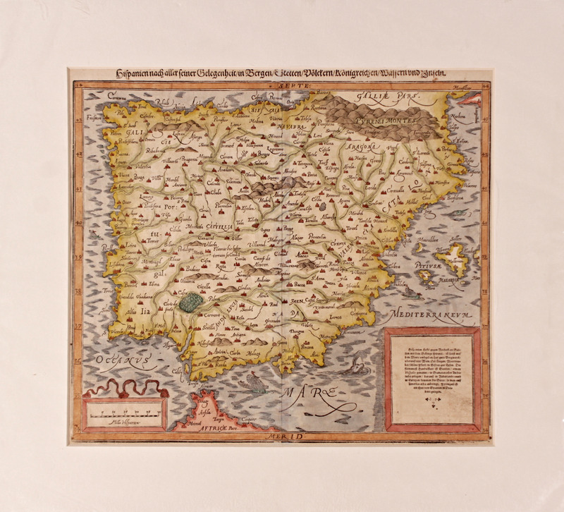
Clique nas imagens para aumentar. MÜNSTER. (Sebastian) CARTOGRAFIA - SÉC. XVI - Hispanien nach Aller Seiner Gelegenheit,in Bergen, Stetten, Völckern, Köonigreichen, Waffern und Inseln. [Basle/ Basileia]. Circa 1550. Cartógrafo: Sebastian Münster Título: Hispanien nach Aller Seiner Gelegenheit, in Bergen, Stetten, Völckern, Königreichen, Wässern und Inseln. [Hispânia com todas as suas divisões administrativas, montes, cidades, povos, reinos, mares e cursos de àgua e ilhas]. Dimensões: Mancha Gráfica: 32.5x37 cm. Com passpartout: 44,5x 49,5 cm Local e Ano: Basileia, ca. 1550 Estado: Em muito bom estado, sem danos, com impressão e coloração muito nítidas. Um dos primeiros mapas da Península Ibérica, xilografado e colorido à mão, publicado na edição alemã da “Cosmographia” de Sebastian Münster. Nomeia as diversas regiões da Península (Portugal, Andaluzia, Galiza, Aragão, entre outras), cidades, as cadeias montanhosas, apresentando também as principais estradas e rios. No canto inferior direito encontra-se uma cartela com a descrição em alemão de diversas características da região cartografada, incluindo os limites geográficos (os Pirinéus a nordeste, o mar Mediterrâneo a sul e o Oceano Atlântico a norte e oeste) e referência a diversas actividades, produtos e fauna da região como a actividade mineira, o vinho, figos, os “belos” cavalos, entre outros. No canto inferior esquerdo, uma cartela decorada com a escala em milhas hispânicas. As margens do mapa apresentam uma escala graduada à esquerda e à direita. Na margem superior a palavra SEPT [Setentrional ou Norte] e na margem inferior MERID [Meridional ou Sul]. No verso uma xilogravura com cabeção decorativo e a legenda em alemão “Hispania newlich beschriben nach gelegenheit Dieser jetzigen Zeit”. Sebastian Münster (1488-1552) foi um cosmógrafo e professor de Hebreu em Tübingen, Heidelberg e Basileia. Münster conhecia diversos académicos e eruditos que lhe proporcionaram diversas descrições geográficas, mapas e conselhos. O primeiro mapa publicado por Münster foi um mapa da Alemanha em 1525. Três anos depois publica um tratado sobre relógios de sol. Em 1540 publica a “Geographia universalis vetus et nova”, uma versão actualizada da “Geographia” de Ptomoleu. Münster adicionou 21 novos mapas aos mapas de Ptomolomeu. Uma das inovações de Münster foi a inclusão de um mapa por cada continente, um conceito que viria a influenciar Ortelius e outros cartógrafos. A “Geographia teve três outras edições: em 1542, 1545 e 1552. A sua obra mais conhecida foi a “Cosmographia universalis” com a sua primeira edição em 1544, tendo tido pelo menos mais 35 edições até 1628. Foi a primeira descrição do mundo em alemão e continha 471 xilogravuras e 26 mapas num total de seis volumes. Esta obra foi amplamente usada durante os séculos XVI e XVII e influenciou o pensamento geográfico de várias gerações.
Title: Hispanien nach Aller Seiner Gelegenheit, in Bergen, Stetten, Völckern, Königreichen, Wässern und Inseln. [Hispania with all its administrative divisions, hills, cities, peoples, kingdoms, seas and water courses and islands]. Graphic Dimensions: 32.5x37 cm. With passpartout: 44.5x49.5 cm. Place and Year: Basel, ca. 1550. Condition: In very good condition, no damage, with very clear printing and colouring. One of the first maps of the Iberian Peninsula, xylographed and handcoloured, published in the German edition of Sebastian Münster's "Cosmographia". It names the different regions of the Peninsula (Portugal, Andalusia, Galicia, Aragon, among others), cities, the mountain ranges, and also the main roads and rivers. In the lower right corner there is a cartouche describing in German several characteristics of the mapped region, including the geographical limits (the Pyrenees to the north-east, the Mediterranean Sea to the south and the Atlantic Ocean to the north and west) and reference to several activities, products and fauna of the region such as mining, wine, figs, the "beautiful" horses, among others. In the lower left corner, another decorated cartouche with the scale in Hispanic miles. The edges of the map have a graduated scale on the left and right. On the upper margin the word SEPT [Northern or North] and on the lower margin MERID [Southern or South]. On the back a woodcut with a decorative headpiece and the German legend "Hispania newlich beschriben nach gelegenheit Dieser jetzigen Zeit". Sebastian Münster (1488-1552) was a cosmographer and teacher from Hebrew in Tübingen, Heidelberg and Basel. Münster knew several scholars who provided him with various geographical descriptions, maps and advice. The first map published by Münster was a map of Germany in 1525. Three years later he published a treatise on sundials. In 1540 he published "Geographia universalis vetus et nova", an updated version of Ptomoleu's "Geographia". Münster added 21 new maps to Ptomolomeu's maps. One of Münster's innovations was the inclusion of one map for each continent, a concept which would influence Ortelius and other cartographers. “Geograpia” had three other editions: in 1542, 1545 and 1552. His best known work was "Cosmographia universalis" with its first edition in 1544, having had at least 35 more editions until 1628. It was the first description of the world in German, and contained 471 woodcuts and 26 maps in a total of six volumes. This work was widely used during the 16th and 17th centuries and influenced the geographical thinking of several generations. Referência: 2007JC001
Local: SDC - CAV 1 Indisponível Caixa de sugestões A sua opinião é importante para nós. Se encontrou um preço incorrecto, um erro ou um problema técnico nesta página, por favor avise-nos. 
Outras Sugestões
|
Pesquisa Simples


|
|||||||
 |
||||||||
|
 English
 Cartographer: Sebastian Münster