

Home |
Temáticas |
Catálogos |
Pedidos |
| |
|||||||
|

|
RUGENDAS. (Johann Moritz) HABITANTE DE GOYAS, QUADRO A ÓLEO PINTADO SOBRE MADEIRA. |
|
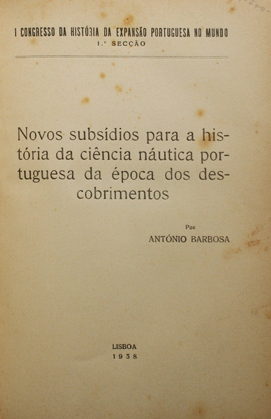
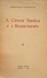
Clique nas imagens para aumentar. BARBOSA. (António) NOVOS SUBSÍDIOS PARA A HISTÓRIA DA CIÊNCIA NÁUTICA PORTUGUESA DA ÉPOCA DOS DESCOBRIMENTOS.I Congresso da História da Expansão Portuguesa no Mundo. 1ª Secção. Porto. Sociedade Nacional de Tipografia. Lisboa. 1938. De 25x18 cm. Com 265, [ii] págs. Encadernação com a lombada e os cantos em pele com ferros a ouro nas pastas e com nervos rótulos e elaborados ferros a ouro na lombada. Folhas de guarda em papel decorativo marmoreado. Corte das folhas carminado à cabeça. Ilustrado a preto e branco no texto com 39 mapas, diagramas e projecções dos métodos da cartografia náutica portuguesa e em extratexto com 5 mapas desdobráveis impressos em papel couché. Exemplar preserva as capas e lombada de brochura. Com ex-libris de Nuno Francisco Sttau Monteiro Ferreira da Silva colado no verso da pasta anterior. Apresenta ligeiros picos de acidez na capa de brochura, folhas de anterrosto e de rosto. Trabalho apresentado pelo autor ao I Congresso da Expansão Portuguesa no Mundo. Obra capital para o estudo da ciência náutica em Portugal, em que se perscrutam as origens da navegação astronómica e do desenvolvimento das cartas de marear na Europa, tendo por base as técnicas e registos dos pilotos do Mediterrâneo a partir do século XIV. O autor privilegia a confrontação de fontes e de teses académicas em torno do tema, equacionando quais os maiores préstimos estrangeiros para o incremento da náutica portuguesa, analisando bibliografia e mapas, descrevendo técnicas e instrumentos e, finalmente, intuindo àcerca do papel dos monarcas portugueses, do Infante D. Henrique e da Escola Náutica de Sagres para a evolução da cartografia e do conhecimento geográfico humano nos séculos XV e XVI.
Illustrated in the texto, in black and white, with 39 maps, diagrams and projections of the methods of Portuguese nautical cartography and hors-texte with 5 fold-out maps printed on coated paper. Copy preserves the paperback covers and spine. With ex-libris from Nuno Francisco Sttau Monteiro Ferreira da Silva pasted on the front pastedown. Slight peaks of acidity on the front cover and title page. Presented by the author at the First Congress of Portuguese Expansion in the World. A key work for the study of nautical science in Portugal, in which the origins of astronomical navigation and the development of sea charts in Europe are scrutinised, based on the techniques and records of Mediterranean pilots from the fourteenth century onwards. Key work for the study of nautical science in Portugal, in which the origins of astronomical navigation and the development of sea charts in Europe are scrutinised, based on the techniques and records of Mediterranean pilots from the fourteenth century onwards. The author favours the confrontation of sources and academic thesis around the theme, equating which were the major foreign contributions to the development of Portuguese nautical science, analysing bibliography and maps, describing techniques and instruments and, finally, intuition about the role of the Portuguese monarchs, Infante D. Henrique and the Escola Náutica de Sagres on the evolution of cartography and human geographic knowledge in the 15th and 16th centuries. Referências/References: Torre do Tombo, SV 2943. BNP, S.A. 38806 V. Referência: 2107AD019
Local: M-3-C-38 Caixa de sugestões A sua opinião é importante para nós. Se encontrou um preço incorrecto, um erro ou um problema técnico nesta página, por favor avise-nos. 
Outras Sugestões
|
Pesquisa Simples


|
|||||||
 |
||||||||
|
 English
 25x18 cm. 265, [ii] pp. Binding with leather spine and corners, raised bands with label and elaborate lettering on spine, and with gilt tools on the boards. Marbled decorative paper covers. Top red edges.