

Home |
Temáticas |
Catálogos |
Pedidos |
| |
|||||||
|

|
RUGENDAS. (Johann Moritz) HABITANTE DE GOYAS, QUADRO A ÓLEO PINTADO SOBRE MADEIRA. |
|
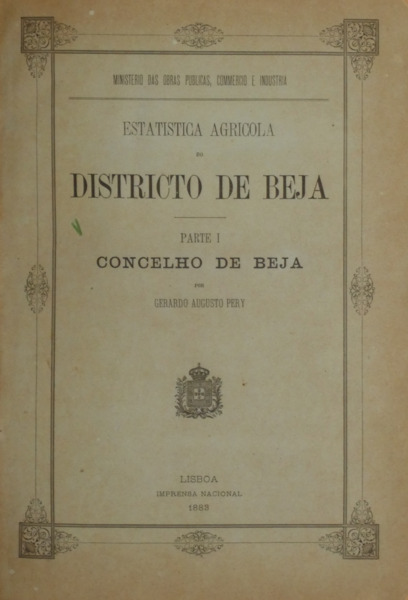
Clique nas imagens para aumentar. PERY. (Gerardo Augusto) ESTATISTICA AGRICOLA DO DISTRICTO DE BEJA. PARTE I, CONCELHO DE BEJA. [CUBA, ALVITO, VIDIGUEIRA, 4 VOLUMES]Por... Ministerio das Obras Publicas, Commercio e Industria. Imprensa Nacional. Lisboa. 1883, 1884, 1885, 1887. 4 Volumes encadernados em um de 29,8x21,3 cm. Com 53, [ii], [iv]; 55, [iv]; 57, [iv]; [iv], 82, [iv] págs. Encadernação da época com a lombada em pele com ferros a ouro. Profusamente ilustrados, no texto, com tabelas dos custos dos trabalhos de levantamento, da população por freguesias e por hectares cultivados, quantidade de prédios rústicos e dos respectivos proprietários, os valores das produções, despesa da cultura dos diversos cereais, na fava e no grão, das vinhas, olivais e mais de uma dezena de pormenorizados mapas estatísticos da produção agrícola do concelho de Beja. Em extratexto, todos os volumes estão ilustrados com duas cartas geográficas, cada um, a cores e de grandes dimensões (61x54 cm.), (54x76 cm.). Exemplar preserva as capas de brochuras dos 4 volumes. Com assinaturas de posse nas folhas de rosto de todos os volumes e na capa de brochura do quarto volume. Os volumes segundo a quarto têm acrescentado nas capas de brochuras e nas folhas de rosto a seguinte informação: [Obra] Iniciada sendo Presidente do Conselho de Agricultura de Beja o Governador Civil, Engenheiro de Minas Pedro Victor da Costa Sequeira. Os mesmos volumes referem que foram elaborados pelo autor nos anos de 1883, a 1885. Trabalho de geografia agrícola muito importante pelo vasto número de pormenorizadas informações estatísticas sobre a agricultura no distrito de Beja na segunda metade do século XIX. Gerardo Augusto Pery de Linde (Lisboa, 1835 - Queluz, 1893) foi um militar de engenharia do Exército Português que atingiu o posto de general. Distinguiu-se no campo da estatística, da geografia e da cartografia. Foi sócio da Sociedade de Estatística de Paris (Société de Statistique de Paris) e da Academia das Ciências de Lisboa. Gerardo Augusto Pery introduziu o conceito de «sistema montanhoso» na geografia portuguesa, quando em 1875 procedeu ao agrupamento das serras em «sistemas». A sua influente obra Geographia e Estatística Geral de Portugal e Colónias foi muito seguida como fonte por múltiplos autores de manuais escolares de geografia, contribuindo para a popularização do conceito de «sistema montanhoso». Trabalhou no primeiro levantamento geodésico do território português, dirigindo a instalação da primeira rede de marcos geodésicos. Foi co-autor da muito referenciada Carta geográfica de Portugal, editada em 1865, que acabou por determinar a uniformização da toponímia de muitos acidentes geográficas, com destaque para as serras e montes.
Profusely illustrated in text with tables of the costs of the survey work, the population by parish and by cultivated hectares, the number of rural buildings and their respective owners, the production values, expenditure on the cultivation of various cereals, broad beans and grain, vineyards, olive groves and more than a dozen detailed statistical maps of agricultural production in the municipality of Beja. Hors-texte, all the volumes are illustrated with two geographical maps each, in colour and of large dimensions (61x54 cm.), (54x76 cm.). Copy preserves the paperback covers of all 4 volumes. With handwritten ownership titles on the title pages of all volumes and on the paperback cover of the fourth volume. The second to fourth volumes have the following information added to their covers and title page: [Work] Started when the Civil Governor, Mining Engineer Pedro Victor da Costa Sequeira, was President of the Agriculture Council of Beja. The same volumes state that they were prepared by the author in the years 1883, to 1885. Very important work on agricultural geography for the vast number of detailed statistical information on agriculture in the district of Beja in the second half of the 19th century. Gerardo Augusto Pery de Linde (Lisbon, 1835 - Queluz, 1893) was a military engineer in the Portuguese Army who attained the rank of general. He distinguished himself in the field of statistics, geography and cartography. He was a member of the Paris Statistical Society (Société de Statistique de Paris) and of the Lisbon Academy of Sciences. Gerardo Augusto Pery introduced the concept of "mountain system" in Portuguese geography, when in 1875 he grouped the mountains into "systems". His influential work Geographia e Estatística Geral de Portugal e Colónias was widely followed as a source by multiple authors of geography textbooks, contributing to the popularization of the concept of "mountain system." He worked on the first geodesic survey of Portuguese territory, directing the installation of the first network of geodesic landmarks. He was co-author of the much referenced Carta geográfica de Portugal, published in 1865, which eventually determined the standardization of the toponymy of many geographical features, especially the mountains and hills. Referência: 2302PG007
Local: M-12-A-14 Caixa de sugestões A sua opinião é importante para nós. Se encontrou um preço incorrecto, um erro ou um problema técnico nesta página, por favor avise-nos. 
Outras Sugestões
|
Pesquisa Simples


|
|||||||
 |
||||||||
|
 English
 4 Volumes bound in one of 29.8x21.3 cm. 53, [ii], [iv]; 55, [iv]; 57, [iv]; [iv], 82, [iv] pp. Contemporary binding with leather spine with gilt tools.