

Home |
Temáticas |
Catálogos |
Pedidos |
| |
|||||||
|

|
RUGENDAS. (Johann Moritz) HABITANTE DE GOYAS, QUADRO A ÓLEO PINTADO SOBRE MADEIRA. |
|

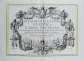
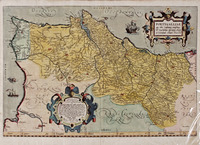
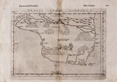
Clique nas imagens para aumentar. ATLAS DE PORTUGAL ULTRAMARINO E DAS GRANDES VIAGENS PORTUGUESAS DE DESCOBRIMENTO E EXPANSÃO.Ministério das Colónias. Junta das Missões Geográficas e de Investigações Coloniais. Lisboa. MCMXLVIII [1948]. De 49x37 cm. Com [x], 236, [iii] págs. não numeradas. Encadernação do editor em tela, com lombada em pele e ferros a ouro nesta e nas pastas. Ilustrado com 110 cartas geográficas a cores, de grande qualidade, impressas sobre papel muito encorpado. Exemplar com rasgos e falhas de pele na lombada, encontrando-se a mesma parte em vias de se soltar. Tem assinatura de posse manuscrita na folha de guarda anterior, datada de 6 de Setembro de 1950. Edição de grande beleza e uma importante fonte para o estudo dos descobrimentos portugueses, dos territórios sob administração de Portugal, em todo o mundo e para a história e língua portuguesa, em cada um dos novos países que se tornaram independentes a partir de 1975. Este atlas foi editado como uma reedição e extensa ampliação da obra «Atlas Colonial», editado em 1914 pela Comissão de Cartografia do Ministério das Colónias. O Atlas documenta outros aspectos, além dos estritamente geográficos, através de cartas: hipsométricas, demográficas, etno-linguísticas, geológico-minerais, fitogeográficas, de actividades económicas, de relações económicas (exportações e importações). Também inclui, ao início, «esquemas das grandes viagens» dos descobrimentos portugueses. As páginas finais contêm uma tabela das entidades que colaboraram na elaboração da obra. Gravura e impressão realizadas entre 1940 e 1946 no Instituto Geográfico e Cadastral sob a direcção de António G. da Graça Costa, chefe da Secção de Publicação de Cartas, tendo a comissão executiva sido presidida pelo engenheiro José Bacellar Bebiano.
49x37 cm. [x], 236, [iii] unnumbered pp. Publisher's canvas binding, with leather spine with gilt tools. Gilt tooled at boards. It is illustrated with 110 high quality colour maps printed on very thick paper. Copy with tears and leather faults on the spine, coming loose. Handwritten ownership title on the front flyleaf, dated September 6, 1950. Edition of great beauty and an important source for the study of the Portuguese discoveries, the territories, all around the world, under the administration of Portugal and for the history and language (namely portuguese), of each of the new countries which became independent after 1975. This atlas was edited as a reprint and extensive enlargement of the work "Colonial Atlas", published in 1914 by the Cartographic Commission of the Ministry of Colonies. The Atlas documents aspects other than the strictly geographical, through charts: hypsometric, demographic, ethno-linguistic, geological-mineral, phytogeographic, economic activities, economic relations (exports and imports). It also includes, at the beginning «esquemas das grandes viagens (major travel schemes)» of the Portuguese discoveries. The final pages contain a table of the entities that collaborated in the elaboration of the work. Engraving and printing carried out between 1940 and 1946 at the Instituto Geográfico e Cadastral [Geographic and Land Registry Institute] under the direction of António G. da Graça Costa, head of the Department of Map Edition, and the executive committee was chaired by engineer José Bacellar Bebiano. Referência: 2211SB001
Local: M-grande formato-8/9-1 Indisponível Caixa de sugestões A sua opinião é importante para nós. Se encontrou um preço incorrecto, um erro ou um problema técnico nesta página, por favor avise-nos. 
Outras Sugestões
|
Pesquisa Simples


|
|||||||
 |
||||||||
|
 English
 Atlas of the Portuguese Overseas Possessions